- Click trail:
- > Home
- > FleetTracker
Rapidsoft Auto and Fleet Tracker System
Rapidsoft Systems' Rapid GTS™ ("GPS Tracking System") is a powerful
system specifically designed to provide web-based
GPS
tracking services for a "fleet" of vehicles.
The system can track vehicles in any country with powerful mapping features.
The types of vehicles and assets tracked include
taxis,
delivery vans,
trucks/trailers,
farm equipment,
personal vehicles,
service vehicles,
containers,
ships,
ATVs,
personal tracking,
cell phones,
and more.
While Rapid GTS™ is very versatile. It can not only meet the needs of an entry-level fleet tracking system,
it is also very highly configurable and scalable to larger enterprises as well. The heart of our GPS system is based
on a tracking software which has been put to use in over 90+ countries
around the world to track many 1000's of vehicles/assets around all 7 Continents.
Current Features:
Rapid GTS™ not only supports the data collection and storage of GPS Tracking and
Telemetry data from remote devices, but also includes the following rich set of features:
- Web-based authentication:
Each account can support multiple users, and each user has its own login password and controlled
access to sections within their account.
- GPS tracking device independent:
Devices from different manufacturers can be tracked simultaneously.
Support for the following GPS tracking devices is included with RapidGTS:
- Aspicore GSM Tracker
(Nokia, Samsung, Sony Ericsson phones)
- Sanav GC-101, MT-101, and CT-24 Personal Tracker (HTTP-based protocol)
Sanav GX-101 Vehicle Tracker (HTTP-based protocol)
- V-Sun 3338 Personal Tracker
- GPSReader GPS data logger with automatic
Wi-Fi upload, for in-cab Windows-based computers.
- Certain Boost Mobile phones
(OpenDMTP compliant)
- Android App
"GPS2RapidGTS"
- HP hw6965 Windows/CE phone (OpenDMTP compliant)
- TAIP (Trimble ASCII Interface Protocol).
- ZhongShan Technology Co, Ltd. "SIPGEAR" tracking devices.
- Most TK102/TK103 tracking devices (those using the common TK102/TK103 protocols).
- TrackStick GPS data logger
- "GPSMapper" capable phones.
- "NetGPS" capable devices.
- iCare G3300 Personal Tracker.
- Some Mologogo capable phones.
With custom coding, other devices can also be integrated as well using the included example "template"
device communication server.
- Customizable web-page decorations:
The look and feel of the tracking web site can easily be customized to fit the motif of the specific company.
- Customizable mapping service:
RapidGTS comes with support for OpenLayers/OpenStreetMap
in addition to support for Google Maps, Microsoft Virtual Earth, and Mapstraction (which
provides mapping support for MultiMap, Map24, MapQuest, and more).
Within the RapidGTS framework, other mapping service providers can also easily be integrated.
- Customizable reports:
Using an internal XML-based reporting engine,
detail and summary reports can be customized to show historical data for a specific vehicle,
or for the fleet.
- Customizable geofenced areas:
Custom geofenced areas (geozones) can be set up to provide arrival/departure notification (additional coding may be required).
Each geozone can
also be named to provide a custom 'address' which is displayed on reports when inside the geozone
(for instance "Main Office").
- i18n Compliant:
RapidGTS is i18n compliant
and supports easy localization (L10N)
to languages other than English. Languages supported currently include
Dutch,
English,
French,
German,
Greek,
Hungarian,
Italian,
Portuguese,
Romanian,
Russian,
Slovak,
Spanish,
Serbian,
and Turkish.
Example Screen Shot:
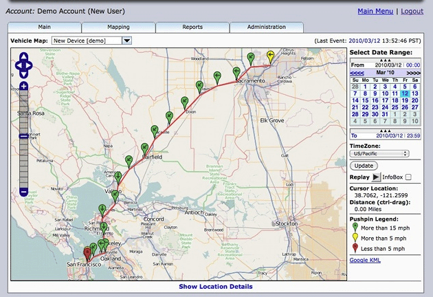
GPS Fleet Tracker
Additional Features:
Event notification & Geo Fencing:
Advanced "Rules-based" event notification based on predetermined criteria from received events.
For instance, an email could be sent if a vehicle is outside a geofenced area on a weekend.
Stateline border crossing:
Ability to record and report state-line border crossings for fuel tax purposes.
Web Interface Based SMS or Call Initiation:
RapidGTS can support functions such as sending an SMS to drivers. Initiating Web based calls to drivers.
Understanding GPS Technologies for Fleet Tracking
Questions below provide some ideas of how GPS works and can help you in understanding the technologies
What is the best GPS tracking/telematic hardware?
The best hardware greatly depends on the specific requirements for the GPS tracking/telematic application.
Here are some of the questions that need to be answered to best fit the GPS tracking/telematic hardware to
the applicaton:
- Is the device for personal tracking, vehicle-installed tracking, or for rarely-moved-asset (RMA)
tracking? Personal tracking devices are self-contained, while devices used for vehicle tracking
usually require specialized installation. For personal tracking, a cell phone tracking
application may be adequate, however battery-life requirements should be considered, as well as
the fact that cell-phone tracking applications can usually be stopped by the operator.
- What are the application power requirements for the device?
Does it need to be self-powered (ie. for tracking untethered trailers, etc.), or is a power-source available?
- Is notification of digital inputs required? (such as door open/closed events, etc).
- Is notification of analog inputs required? (such as temperature, fuel level sensors, etc).
- Does the application require the ability to query the location of the device, or send commands to the device?
- Does the application require the ability to set digital 'outputs' on the device? (ie. unlock doors,
disable starter, etc).
- Does the device need to store unsent events (due to loss of coverage) until connection to the
server can again be obtained? (often called "store-and-forward").
- What are the data transport requirements for the device? (ie.
TCP,
UDP,
SMS,
Satellite,
WiFi,
Bluetooth,
etc.)
- Is text-based communication with the operator or driver of the vehicle required?
- Is voice-based communication with the operator or driver of the vehicle required?
- Does the application require the ability to send 'next-stop' information to the driver,
with navigation to the next stop?
- Is the cell phone coverage area adequate for the application? (ie. will the
GSM/GPRS
or CDMA
wireless data provider cover the areas that you require)
- Is satellite-based communication required? (ie. for areas that do not have adequate GSM/GPRS or CDMA coverage).
Satellite-based communication options include
Iridium,
OrbComm,
Globalstar,
and
Theraya.
- Is engine diagnostic information required, including actual odometer, fuel usage, engine temperatures, etc? (ie.
J1708,
J1939,
OBDII,
EOBR,
CANBus)
- Is temperature monitoring information required? (ie. refrigerated containers, etc.)
- Does the device need to be PTCRB certified?
(This is a question often overlooked. In the US, all tracking devices which transmit data over a
wireless modem need to be PTCRB certified.)
- etc.
Each of these features potentially has an additional cost associated with it as well.
The more features required, the more costly the solution, and the cost of the solution will need to be
weighed against the benefit of the information that it provides.
Once the required features have been determined, the search for the best device that fits
the requirements can begin.
How many devices can RapidGTS track?
RapidGTS has been successfully used to track thousands of devices on a single server. Here are some
of the factors that can effect the number of devices that a single server can track:
- TCP vs. UDP - A TCP 'session' consumes more resources that a UDP connection, especially if the device
always expects to maintain a constantly connected TCP session. Using UDP for data transport is
more scalable and is the recommended method of sending data from the device to the server.
- Event Reporting Interval - A more frequent reporting interval will have a higher load on the system.
If 1000 devices transmit location data once every 5 minutes (300 seconds), this averages about 3.33
messages per second arriving at the server (1000 devices / 300 seconds). However, if the same 1000
devices needed to transmit data every 20 seconds, that averages about 50 messages per second (1000
devices / 20 seconds), creating a much higher load on the system.
- Network Speed - The Internet service provider, and/or local Intranet speeds also effect the ability
of the server to receive data from the remote devices, and still perform other network queries that
it may need for any required event analysis.
- Computer Resources - The more RAM that a computer system has installed, generally the faster it will run.
It is recommended that a system running RapidGTS have at least 2Gb of RAM installed.
These are only guidelines, and a system tracking 1000's of devices, or tracking at a much more frequent
interval, will require more system resources than a system tracking fewer devices at a less frequent
reporting interval.
How is GPS tracking/telematic data sent from the device to the server?
Depending on the capabilities of the device, data can be transmitted to the server in one of several ways.
The following describes some of the methods used by devices to transmit data to the server:
- Cellphone Network - The most common method of transmitting data to the server.
The GPS tracking device contains a Cellphone modem which typically uses a SIM card provided
by a Wireless Data Provider (ie. AT&T, T-Mobile, Sprint, Rogers, etc). The modem uses this wireless data-plan to
establish a connection to Internet, and then a socket connection with the server. Once connected to the server, it typically
sends its location information, then disconnects. Data can be transmitted using UDP or TCP.
Each has their advantages and disadvantages, however UDP is generally preferred due to its much greater data bandwidth efficiency.
In some cases, data may be sent to the server using SMS through the use of
an SMS-Gateway.
The following graphic displays how GPS data may be transmitted to the server over a GPRS/Mobile network:
Example Screen Shot:
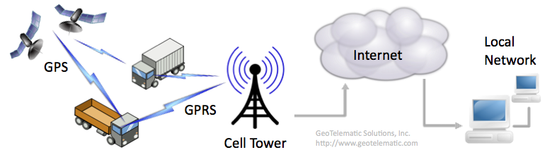
GPS Fleet Tracking
- Satellite Communications - The GPS tracking device contains a satellite modem which connects to one of the major
satellite communication data providers (ie. Iridium, OrbComm, Globalstar, etc.). The data from the tracking device is
sent to an orbiting communication satellite, which then relays the data to a ground station, which then forwards the
data to a server over a stanrd socket connection, or may use
SMTP to forward the data to the server.
Satellite data communications tend to be much more expensive, and have much greater data limitations, than using a cellphone network.
The following graphic displays how GPS data may be transmitted to the server over a Satellite Communication network:
Example Screen Shot:

GPS Fleet Tracking
- WiFi Network - The GPS tracking device contains an 802.11
compiant WiFi modem when connects to a wireless router to send data to the server.
This type of application is typically limited to very localized environments, such as tracking
vehicles traveling within a closed yard, or mining plant.
The advantage with this solution is that there is no associated cost with the tracking of the vehicle, however,
the coverage area is limited to a very specific geographical area.
- Bluetooth - The GPS tracking device contains a Bluetooth modem,
which it uses to connect to a local bluetooth enabled server, or router, to send data to the server.
This type of application tends to be used only in very customized applications.
- Memory Card - The GPS tracking device contains a removable memory card (such as a "Secure Digital (SD)" card).
At the end of the day's travels, the memory card is removed from the device and inserted into a reader which downloads the
data to the server.
The advantage with this solution is that there is no associated cost with the tracking of the vehicle, however,
obtaining near real-time tracking on a map is not possible using this solution.
Once the data is received by the server, the modem-id (ie. IMEI number, etc), or other uniquely identifying number, is used to
associate the event with an account/device on the server. Once the event has been associated with an account/device,
the event is ready for viewing on a report or map.
Price and Licensing
Please contact us for more details on pricing and other custom features. We offer several pricing options - pricing based on size of fleet
(starting as a low as $34.95/per vehicle). Customization charge based on specific customer requirements can be done.